
713.845.5401
ENGINEERING SOLUTIONS
Quality. Innovation. Excellence.
Raymondville Drain
The Raymondville Drain Project, is an authorized federal project with the US Army Corps of Engineers – Galveston District (USACE) under the Project for Flood Control, Lower Rio Grande Basin, Texas, under Title IV, Section 401 of the Water Resources Development Act (WRDA) 1986 and amended by WRDA 2007.
Due to financial capabilities for nonfederal participation, Hidalgo County Drainage District #1 (HCDD1) became the Lead Sponsor (non-federal sponsor) for the Raymondville Drain Project, through a Memorandum of Understanding and Letter of Intent in September 2001 with the USACE.
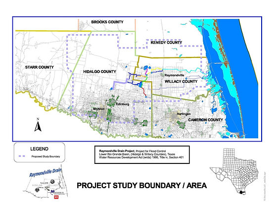
This federal project will play an important role in regional flood protection (affecting a five-county area). It will allow for the continued and future economic development and growth along already developed and potentially flood-prone areas in both Hidalgo and Willacy Counties, as well as contributing watersheds of Starr, Kenedy, and Cameron Counties. Project location map is shown in Figure 1.
As the General Engineering Consultant, S&BI is responsible for coordinating and managing contracts for four engineering firms. This contract includes the development and implementation of Hidalgo County Drainage District No. 1 Master Drainage System Phase II for the design and expansion of the Raymondville Drain Outfall System.
SCOPE OF WORK
The scope of this IDIQ project includes planning, development and implementation of the design and expansion of the Raymondville Drain Outfall System. The project is located within the South Texas drainage basin known as the Lower Rio Grande Basin, Texas, and includes the analysis and proposed improvements associated with three major channels (1) the Raymondville Drain, (2) the North Main Drain, and (3) the Main Floodwater Channel, as well as adjacent laterals and flood control features. The project activities involve advance planning, preliminary engineering and design, final design and plans, specifications, and estimates (PS&E), Right-of-Way (ROW) map preparation, and construction management of proposed improvements. The proposed improvements to the Raymondville Drain include approximately 12 miles of new storage channel/ditch facilities, as well as proposed improvements to 48 miles of existing channels/ditches. Also included along the drainage outfall system, are the proposed improvements involving associated facilities such as bridges, culverts, on and off-line detention facilities, major control structures (gates, weirs, etc.), utility crossings, pump stations and downdrains.
Planning
Planning activities consist of development in accordance with the US Army Corps of Engineers (USACE) Economic and Environmental Principles for Water and Related Lane Resources Implementation Studies; (Principles) and the Economic and Environmental Guidelines for Water and Related Land Resources Implementation Studies (Guidelines) and the National Environmental Policy Act (NEPA).
Drawings
Drawings are developed in MicroStation (.dgn) and AutoCAD (.dwg) formats, as needed.
Inventory of Facilities
Data acquisition and measurement through LiDAR-generated bare-earth digital elevation models (in an ASCII format) at a 6-ft x 6-ft resolution covering approx. 894-sq. miles, aerial photogrammetry, field surveying (including GPS), and obtaining I converting appraisal ACAD files with vector representation of more than 90,000 parcels into GIS shapefile georeferenced into the project coordinate system (State Plane, Texas South NAD 83, US Feet)
Engineering Planning
Planning studies (pre-/post-authorization, general reevaluation report, NEPA documentation (investigations and EIS), alternatives analysis, including risk-based analysis, NED-benefit analysis, socio-economic profile and impact assessment, ability to pay I financial analysis, plan formulation and scheduling for final project development, operation and maintenance, and construction; development of a public involvement plan; stakeholder participation; project scoping; coordination with regulatory and resource agencies; and proposed mitigation plans.
Engineering Design
Conceptual, preliminary, and final designs of proposed improvements to selected alternative. Design for rehabilitation, renovation, repair and new construction for civil works associated with surface and subsurface water, flood reduction and control, including channels, levees, detention (linear, ponds, basins, and lakes), flood-proofing and buy-out, and water resources; preparation of plans, specifications, and estimates; bidding assistance; and construction support services.
Interagency coordination with FEMA, USIBWC, USACE, USDA, USFWS, TCEQ, TxDOT, THC, TP&W, and TWDB.
Engineering Software
H&H (HEC-RAS, HEC-HMS), including watershed analysis, groundwater and surface, flood routing, backwater, reservoir, water quality, scour analysis, and flood zone determination.
Schedule
As part of HCDD1's agreement with the USACE, the USACE would develop the downstream portion of the Project, and the HCDDl 's consultant (S&BI) would develop the upstream portion of the Project. However, in accordance with federal guidelines, the Raymondville Drainproject must be developed as a whole project (downstream and upstream) during the planning studies. Due to the inadequate funding of the USACE for their portion of the project, the Raymondville Drain project has incurred significant delay. To expedite completion of the project, HCDD1 invoked General Section 211 provisions under WRDA, whereby HCDD1 would take over the USACE's portion of the project. Specific activities and anticipated year of completion is shown in the Table shown below.
It is proposed, with funding and agency approval, that the planning, design, and construction of the Raymondville Drain Project can be completed in approximately the next seven years.